

» Destination's informations
Back to map �Connecticut
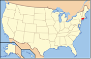
 Connecticut is a state in the New England region of the northeastern United States. It is bordered by Rhode Island to the east, Massachusetts to the north, and New York to the west and south (because various islands of New York span Connecticut's entire coast).
Southwestern Connecticut is part of the New York metropolitan area; three of Connecticut's eight counties, including most of the state's population, are in the New York City combined statistical area, commonly called the Tri-State area. Connecticut's center of population is in Cheshire, New Haven County.
Connecticut is the 29th most populous state, with 3.5 million residents, and is ranked 48th in size by area, making it the 4th most densely populated state. Called the Constitution State and the Nutmeg State, Connecticut has a long history dating from early colonial times and was influential in the development of the federal government of the United States.
 Also known as : The Constitution State, The Nutmeg State, The Blue Law State
Capital : Hartford
Largest city : Bridgeport
Population : 3 501 252
Abbreviation : CT
Main cities : Bridgeport, Hartford, New Haven, Waterbury, Stamford/Greenwich, New London, Norwich, Danbury

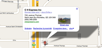
 743, Avenue Thomas